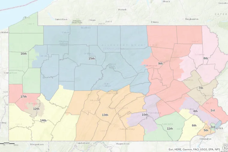
The Effect of PA’s New Congressional Map on Lower Merion
As midterm elections approach, many political office-holders are scrambling to give their party the upper hand, and this holds especially true in our swing state of Pennsylvania. The political polarization that ravages our nation is just as rampant locally, as for the past couple of months, our Democratic Governor Tom Wolf has been engaged in a fierce battle with our Republican General Assembly over our new congressional map. Breaking the stalemate, the Pennsylvania Supreme Court stepped in on Wednesday, and in a 4-3 decision, the majority Democrat court selected the congressional map designed to cause the “least change”.
Designed by esteemed Stanford professor, Jonathan Rodden, the accepted map was proposed by a Democratic plaintiff, invoking protest from Pennsylvania Republicans. These cries of outrage were only heightened when, in accordance with our state’s relatively stagnant population census, Pennsylvania lost a seat in the House of Representatives, and the redistricting plan combined two Republican Pittsburgh-area districts, effectively pinning these Republican incumbents against each other.
Pennsylvania’s Republican Committee threw a mild temper tantrum in response to the snubbing of their favored congressional map, which was previously approved by a lower-court conservative judge, childishly referring to the court’s decision as a “partisan choice”. Despite this hissy fit, the new map is advantageous for the Grand Old Party, creating eight Republican-leaning districts, six Democratic-leaning districts, and three closely divided districts.
The new congressional map is a refreshing contrast from the heavily gerrymandered districts drawn by Republican legislatures in the past, presenting benefits for Pennsylvania Democrats and Republicans alike. While this map could prove to be effective in freeing our state from its partisan shackles, our own community of Lower Merion Township faces a very different experience. Under the new congressional map, we are split right down the middle between Congressional Districts 4 and 5, represented by Congresswomen Madeleine Dean and Mary Gay Scanlon, respectively.
While many Harriton students just see Old Gulph Road as one street on the route they take to school every day, it is now the dividing line between Congressional Districts 4 and 5, with District 5 to the left of Old Gulph Road and District 4 to the right. Though each district’s borders are drawn erratically, District 4 essentially comprises Gladwyne, Rosemont, Penn Valley, Bala Cynwyd, and Merion Station, while District 5 consists of Villanova, Bryn Mawr, Narberth, Ardmore, and Wynnewood. Harriton, exactly on the border of the two districts, falls towards the District 4 side.
With Harriton in one district and our counterparts, Lower Merion, in another, it is clear that our community has been divided. I question what this estrangement means for Harriton students who live in Villanova, Bryn Mawr, or any of the other aforementioned District 5 neighborhoods; what is the effect of living in one township and going to school in another?
If a Narberth resident attending Harriton wants to talk about a problem they’ve identified in their school system, do they turn to Congresswoman Dean or Congresswoman Scanlon? If Lower Merion School District requires funding, which representative does it lean on, considering that its ten schools are split evenly between both districts?
Regardless of how the districts fall in Pennsylvania’s new congressional map, it is essential that Lower Merion Township stay united. In an era of such intense political polarization, we mustn’t allow the latest catfight between Republicans and Democrats to tear our community apart.

Arielle is an IB Senior who is very excited for her fourth and final year with The Banner. Outside of The Banner, you can find her telling unfunny jokes...


